The Pine Valley Summit Trail. Also known as "The Death March"
Ever since I started backpacking up on Pine Valley, I've wanted to do the summit trail in its entirety. Start in New Harmony on the Comanche Trail, up across the top, and back down Forsyth canyon into the quaint town of Pine Valley.
I've done several sections as overnighters on the Pine Valley area. The New Harmony side was foreign to me. Anderson Valley, Big Water, Comanche Trail were all unknowns, and there was a lot of country to cover and explore. When looking up at Pine Valley Mountain from St. George it doesn't look like it holds meadows and streams up there. It looks too narrow. Which it is too narrow. Once you hike up from the South side, it almost abruptly drops and descends back down on the north side. It's a rather narrow mountain but it does have some hidden gems.
I had heard rumors about an old cabin built up in Anderson Valley that sheep herders use to use back when they ran sheep up there in the mid 1900's. There was only a couple photos on the inter webs and not much mention of it besides in a few blogs and on google earth.
While researching the area on Google Earth, I stumbled across what looks like another cabin on the top of the Comanche trail. This was the final straw. I needed to go hike this area and see what's going on up there.
I was able to have my friend Cory join me for the hike. The trail is roughly 34 miles. We planned on doing at least 10 miles a day and doing a 3 day hike. Mileage is tricky on this mountain. You can't just hike till you're done and set up camp. Water is sparse up there and is only found in a few spots. Luckily there is sources every 5-7 miles into mid summer.


 North Valley
 Browse lookout


I've done several sections as overnighters on the Pine Valley area. The New Harmony side was foreign to me. Anderson Valley, Big Water, Comanche Trail were all unknowns, and there was a lot of country to cover and explore. When looking up at Pine Valley Mountain from St. George it doesn't look like it holds meadows and streams up there. It looks too narrow. Which it is too narrow. Once you hike up from the South side, it almost abruptly drops and descends back down on the north side. It's a rather narrow mountain but it does have some hidden gems.
I had heard rumors about an old cabin built up in Anderson Valley that sheep herders use to use back when they ran sheep up there in the mid 1900's. There was only a couple photos on the inter webs and not much mention of it besides in a few blogs and on google earth.
While researching the area on Google Earth, I stumbled across what looks like another cabin on the top of the Comanche trail. This was the final straw. I needed to go hike this area and see what's going on up there.
I was able to have my friend Cory join me for the hike. The trail is roughly 34 miles. We planned on doing at least 10 miles a day and doing a 3 day hike. Mileage is tricky on this mountain. You can't just hike till you're done and set up camp. Water is sparse up there and is only found in a few spots. Luckily there is sources every 5-7 miles into mid summer.
Day 1
 |
The Comanche Trail starts just west of the New Harmony Trail head. We crossed through a burn area affected from the Mill Flat fire a few years back. After a mile we enter some mountain mahogany and gamble oak groves that line the trail. It's a refreshing break from the sun to find some shade. The trail is pretty thick, It doesn't see a lot of love and pruning. There is an old Canal system setup if you pay attention that use to provide water to the town below. It looks to now be abandoned for a pipeline that breaks through the ground every now and again. Comanche creek also starts to flow after a couple miles and provides a small water source for parts of the climb. From the New Harmony Trailhead to Quaking Aspen Spring is just over 4 miles. There is a great spring here and plenty of camping spots.
 |
| Looking South on the top of the Comanche Trail as it exits the Canyon. |
 |
| Looking Down Comanche Trail towards Kolob |
 |
| Another Look towards Kolob and New Harmony |
 | |||||||||||||
1/2 mile before Quaking Aspen Spring
|


 | ||
Big Water
|

Day #2
The second day was travelling from Big Water to the Whipple Valley area. We stopped in Mill flat for lunch and to drop our packs off for a side trip to Anderson Valley. I'd heard there was an old cabin up there that sheep herders lived at during the summers back in the 1900's. The summit trail skips passed Anderson Valley but its less then a 2 mile hike over to it via the Anderson Valley Trail.
 | ||
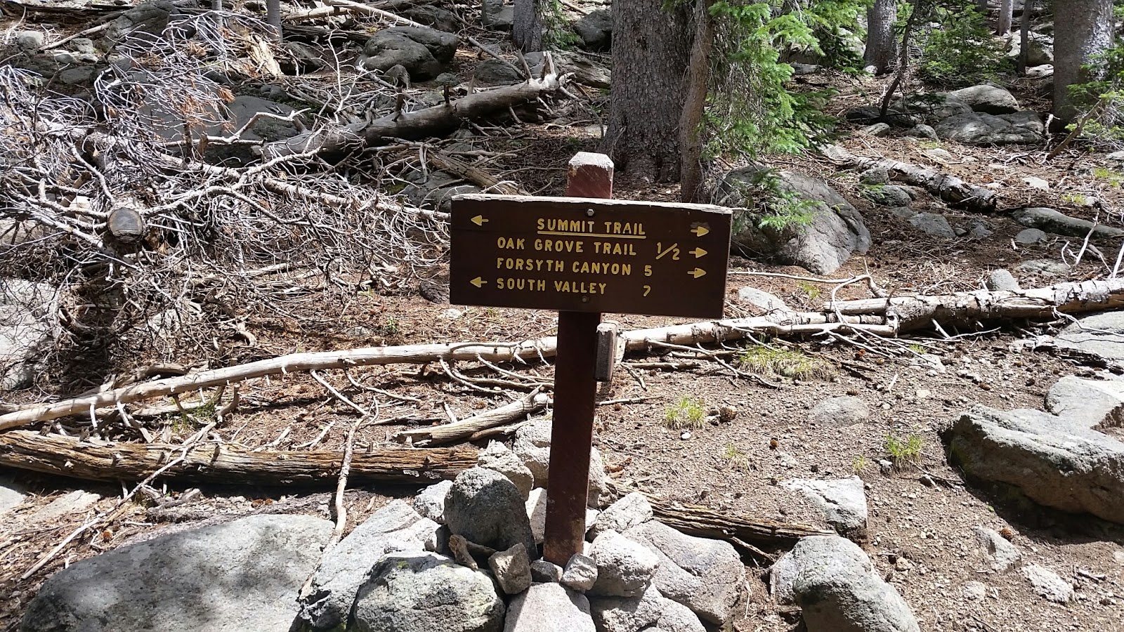
Summit Trail takes a left here. White Rocks Reservoir is down to the right.
 |


Just before Mills Flat you'll start seeing aspens and tall grass.


Mill flat is a long meadow. This is the north side.
Mill flat has water on the south side and heads down Mill Canyon. I've never been in the fall but all summer it has had water. We stashed our packs, grabbed a few snacks and took the Anderson Valley Trail over to Anderson Valley to try and find the cabin. It is just under 2 miles and crosses over a few valleys. The first one from Mills is Dam Canyon which like Mill canyon has water into the summer.

Anderson Valley

Water Rehab project. The fence built out keep animals out is no longer serving its purpose.

Old sheepherders cabin at SW corner of valley.
After the 4 mile trip out and back from Anderson Valley we headed over to our usual camp spot in Mills and set up our hammocks and ate lunch before heading over to the Whipple Valley area.

Typical trail out of Mills

Browse lookout area offers the first real peak down on the I-15 corridor and the black ridge.


The Whipple Valley area is a beautiful section of Pine Valley that offers several meadows. North valley has very unique rocks jetting out of the middle of it, Whipple has a reliable water source through the middle of it and a bailout trail that takes you back down to the Pine Valley campground via the Whipple Trail. South Valley like the others is a beautiful meadow which has a water source although it doesn't last as long as Whipple does.


Whipple Valley
Day #3
We stayed around camp in the morning and enjoyed the scenery before finally packing up and leaving just after 11. This section of the trail is where the trail got the name the death march. The trail from Hidden Valley up to Further Water is a never ending climb with plenty of false tops and steep terrain. We dropped back down twice and have to go right back up on the other side of some steep valleys before meeting up with the Oak Grove trail and the Brown point trail which took us back down to the Pine Valley campground. After leaving Whipple Valley water isn't very reliable until we got to further water. Hidden valley has water in spring and early summer but isn't always around come mid summer.

South Valley

South Valley

Hidden Valley

From Hidden Valley Rock

Steep section of trail climbing out of Hidden Valley
Trail junction in Nay canyon

Further Water

View from the southern edge

Looking down at St. George. The Lakes are very predominant
After Further Water the Summit Trail wraps behind Signal Peak before climbing up near Burger Peak. The views are nothing short of amazing. After the views the trail drops into Forsyth Canyon where it drops off the face of the earth for roughly 7 miles down into the town of Pine Valley.
Would do again.

Great recap of the hike! Hoping to do this in June 2021 starting at Forsyth and ending at the Summit trailhead(instead of heading down Comanche) Cheers!
ReplyDelete